Tongariro Crossing Shuttle
Tongariro Alpine Crossing
NZ’s Greatest One Day Walk 
6-8 hours, 20 km One Way
Grade: Moderate-Difficult
Begins: Mangatepopo (35 minutes drive)
Ends: Ketetahi (25 minutes drive)
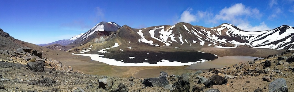
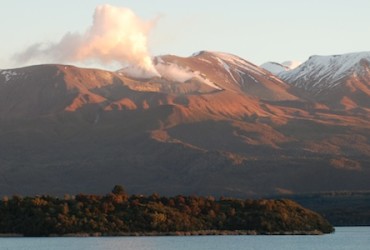
The Tongariro Crossing shuttle delivers you to a spectacular one day adventure through a lunar like landscape of active volcanoes, craters, mountain springs, lava flows, emerald lakes and mounds of volcanic rock. There are views of alpine meadows, mountain summits, stunning volcanic features and on clear days; you can see Mt. Taranaki in the west, Mt. Ngauruhoe (‘Mt Doom’ from the ‘Lord of the Rings’ films), the Kaimanawa Ranges and Lake Taupo.
The Tongariro Crossing shuttle can deliver you to either end of the track, though it is best walked from Mangatepopo to Ketetahi. The walk is unguided in summer and at times winter conditions demand it be tackled as a a guided walk. Riverstone Backpackers can arrange your transport in summer and when necessary your guided service in winter.
The Crossing track is a day-hike section of the Tongariro Northern Circuit Great Walk, and in the right weather conditions offers side trips up either Mt Ngauruhoe or Mt Tongariro. In summer these ascents can be done as part of a longer day trip, which is explained in the track description.
The Northern Circuit is a 3 day trek staying in DOC huts within the park, and offers the opportunity to be close to the volcanoes when the mountains are often quieter. The Tongariro Traverse is an easier and lower altitude option to the Crossing which is a good alternative in more adverse weather.
Tongariro Crossing Shuttle
Booking Your Shuttle
- Riverstone Backpackers will organize your Tongariro Crossing shuttle to the start of the trek at Mangatepopo, pickup from the end of the track at Ketetahi or a fully guided trip in winter – there are no surcharges
- Please book at the Reception window before 7pm or if you are arriving after that time call ahead on your day of arrival to arrange
- The time of year, weather, season and track conditions determine the best and safest way to tackle the Crossing. Please check the weather and seasonal reports, read the track description before starting and make sure you have the right gear
Track Conditions Explained: Guided or Unguided?
1 Tongariro Alpine Crossing transport and guiding has three seasons – summer season, winter season and mid season (autumn-spring) – which determine the best way to tackle the Crossing and the costs involved
2 Shuttle only option (summer conditions) applies when the track is clear from snow and ice
3 Once there is snow and ice on the track we no longer offer shuttle only options for safety reason (winter & mid season conditions)
4 Due to variable weather during the spring and autumn, from day to day any one of these three options may be more appropriate
5 Bus times are subject to change, please check times with Riverstone Backpackers
Weather Conditions
Riverstone Backpackers management keep up to date with weather conditions. As weather conditions in the Tongariro National Park park are very changeable and potentially dangerous, please check on your day of arrival for our assessment of the conditions.
Tongariro National Park Forecast – MetService 5 Day
MetVUW Rain Forecast – MetVUW- 7 Day Rain Forecast
Tongariro Crossing Winter June to September: Fully Guided & Shuttle Only Walking Time: 8 hrs Suitable for moderately fit people Depart Riverstone to Managatepopo: 7.15am Cost: $185 Return Includes: One guide per ten people, mountain gear and return transport …
Tongariro Crossing Spring Autumn September-November & April-June: Semi Guided & Return Shuttle Walking Time: 5-7 hours Suitable for moderately fit people Depart Riverstone to Managatepopo: 6.30am Includes: Safety staff to accompany, use of crampons & ice axe unlikely Cost: Mangatepopo …
Tongariro Crossing Summer November to May: Unguided Shuttle Only Walking Time: 5-7 hours Suitable for moderately fit people Depart Riverstone for Mangatepopo (start of track): 6.15am & 7.15am Return Ketetahi (end of track) to Riverstone: 2.30pm, 3.30pm & 4.30pm Cost: …
Cancellation Policy
- If due to adverse weather your Tongariro Crossing shuttle is cancelled on the morning before departure a full refund will be given
- If after arrival at the mountain the the trip is cancelled by the operator due to adverse weather or you decide to return, a redeemable ‘transport voucher’ will be issued – no refunds will be given
- Your ticket price covers return transport according to the bus timetable, the transport providers are not required to wait for you and no refunds will be given if you miss the bus
Essential Mountain Gear: What You Need To Take
Gear You Need To Bring
- Upper clothing – 3 layers, polypropylene or wool and a waterproof jacket and hat for the season – no cotton. In summer a minimum of 2 layers, even if you carry one in your bag
- Lower clothing – outdoors style light cotton trousers and/or thermal leggings and if necessary rain proof trousers and gloves – no jeans
- Boots with ankle support, no flip flops. While you may be able to walk the track in sports shoes in summer, these provide less ankle support and are not recommended
- Small backpack to carry excess clothing and lunch
- Lunch and 1 litre of water
- Sunglasses, sunscreen and lip balm
- Cell phone – some reception available
Gear Supplied (winter guided only)
- Crampons
- Ice Axe
Rental Gear (available on the bus)
- Day pack
- Raincoat & rain proof trousers
- Fleece thermal top & pants
- Hiking boots & walking poles
Gear for Sale (available on the bus)
- Sunglasses
- Hat, gloves, socks
- Water
Toilet & Rubbish Facilities
- Toilets are situated at Mangatepopo at the beginning of the track, Ketetahi at the end of the track, the Soda Springs, and Ketetahi and Mangatepopo Huts
- Rubbish – no rubbish facilities are provided, please remove all rubbish you bring with you from the park
Walking the Tongario Alpine Crossing 
Track Description & Route Options
Begins: At the end of Mangatepopo Road (7 km off of SH 47)
Grade: Moderate Difficulty -1 Way Day Trek Over Alpine Terrain
Distance: 13km
Time: 6–8hrs
Beginning at 1150m the track winds up the Mangatepopo Valley to the saddle between Tongariro and Ngauruhoe then climbs to Red Crater (1886m), and drops down to the Emerald Lakes. After passing Blue Lake, the track descends around the northern slope of Tongariro, then more steeply in a zig-zag to the Ketetahi Shelter (1454m). The last section is all downhill through tussock plains, and into the native forest near the end of the track at the Ketetahi carpark (750m).
1 Mangatepopo (1150m) to Soda Springs
Time: 1hr
Grade: Easy Walk
This is a very easy beginning with the track following the Mangatepopo Stream over boardwalks with great views of My Ngauruhoe (‘Mt Doom’).
For those with their own transport and in adverse weather, this section offers a safe return day walk from the car park and the option of continuing on to the Soda springs. The toilet facilities here, are the last before the end of the track at Ketetahi.
2 Soda Springs to South Crater (1660m)
Time: 1hr
Grade: Hard Climb
This section climbs fast from 1400-1600m above sea level and is known as the Devil’s Staircase.Take your time as the view down the valley is superb and on a clear day you can see all the way to Mt Taranaki on the west coast near New Plymouth.
At the top you are at the gateway to the South Crater and the start point of the summit sidetrack of Mt Ngauruhoe. Head for the old lava flow as this is the easiest route up the peak.
Ngauruhoe Crater Climb (Summer Only Option)
Height: 2287m
Time: 2hrs return from South Crater, 6-7 hr return from Mangatepopo
Distance: 6 km return from South Crater; 19 km return from Mangatepopo
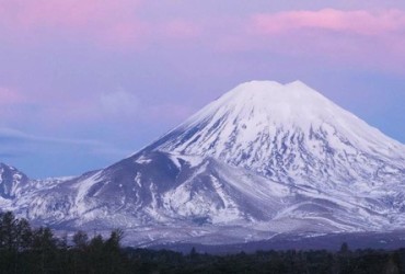
As an interesting side trip from the Tongariro Crossing or as a stand-alone journey from the Mangatepopo road-end, Mt Ngauruhoe (2287m) offers a short demanding climb up a volcanic cone with potentially dangerous scree slopes. Mt Ngauruhoe is also known as ‘Mount Doom’ in the Lord of the Rings films.
This optional sidetrack in not marked all the way, so it should only be attempted if the weather is clear and not too windy or cloudy. To protect yourself from sharp rocks, you should have long pants and ankle boots. Look to the left-hand side about a third of the way up and you will see a solid lava flow to follow on your ascent.
- This track starts at the top of the Devils staircase, is extremely steep and should only be attempted if you found the Devil’s Staircase easy – do not do this if you suffer from vertigo
- To have sufficient time to complete your walk and catch the bus, you will need to start your climb no later than 9.15am and depart from the summit no later than 11:45 am
3 South Crater to base of Red Crater Ridge (1886m)
Time: 10mins
Grade: Easy Walk
- This is the point of no return – if you are having difficulty for any reason, or the weather has closed in and you feel that you need to get down, turn back at the bottom of this ridge and call the bus driver on 07 377 0435.
- If you reach the Red Crater Summit you will be past the most dangerous and difficult part—and if you continue on you will be more sheltered from the elements.
4 Red Crater Ridge
Time: 45 minutes
Grade: Difficult
Follow the poled route across South Crater to a ridge leading up Red Crater. Offers spectacular views of the Oturere Valley, Rangipo Desert, Kaimanawa Ranges and towards the Emerald Lakes.
- Going from the South Crater to the top of the Red Crater is the steepest part of the track.
- This track can be scary when the winds are strong as you may get pushed around or even find you need to be on your hands and knees
- Caution is required as this section of track is steep and has a big drop either side – please do not walk too close to the crater, and stay on the track
Mt Tongariro Summit Climb (Summer Only Option)
Height: 1967m
Time: 1.5 hours return from top of Red Crater
Grade: Easy
From Red Crater follow a poled route to the summit of Mt Tongariro. This is an easy route following an undulating rocky ridge with a great view of Mount Ruapehu from the Tongariro summit.
5 Red Crater Summit to Emerald Lakes
Time: 15mins
Grade: Easy Descent
At the top of the Red Crater you are at the 1886m summit of the Crossing track. This is a good spot for lunch, as the crater is active and there are hot spots to sit on.
To the left you will see an old lava flow from Red Crater spreading out across the floor of Central Crater and to your right are the Emerald Lakes. You can see thermal steam rising around the Red Crater and Emerald Lakes, while the minerals from this area leach into the lakes giving them their iridescent coloring.
6 Emerald Lakes to Blue Lake
Time: 20mins
Grade: Easy
The track follows around the edge of Central Crater then climbs up to Blue Lake (a cold acidic lake).The track to Oturere Hut, part of the Tongariro Northern Circuit track is on the far side of the lowest lake.
When you get to the bottom you will be inside the Central Crater. You will recognise it from the front cover of the brochure. The walk is flat and easy with a mini-climb to the Blue Lake. There is no swimming in the lakes.
7 Blue Lake to Ketetahi Shelter (1454m)
Time: 1hour
Grade: Easy Descent
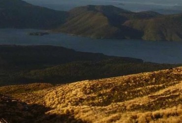
A short climb to the edge of the North Crater with views toward Mount Pihanga and Lake Rotoaira across to Lake Taupo. You then follow the Rotopaunga Valley down the North face to the Ketetahi Shelter (1454m). When you get to the hut you may want to use the rest rooms and enjoy the views to the north.
You can see evidence from the volcanic eruptions in 2012 – excellent views of the new steaming vents at Te Maari craters, impact craters near the track, and damage to the Ketetahi hut.
8 Ketetahi Shelter to Ketetahi Car Park (750m)
Time: 2 hr
Grade: Long Descent Walk
Follow the poled route through the open tussock land to the clearing by the seats where the track drops steeply to the Mangatetipua Stream. A short side track leads down to a waterfall a few minutes before reaching the Ketetahi Car Park (750m). This section is often shrouded in podocarp forest with lots of birdlife.
- You must leave not later than 2.30pm to catch the last Tongariro Crossing shuttle