Lake Rotopounamu & Te Porere Redoubt
Lake Rotopounamu & Te Pōrere Redoubt
Forested Lake Walk, Maori Fortifications & Mountain Views
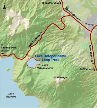
Lake Rotopounamu Track Access
Lake Rotopounamu and Mt Pihanga are central to the rich history and culture of the Tongariro Region. The area is within the 5000ha Pihanga Scenic Reserve, which was added to the Tongariro National Park in 1975 and so the reserve is also part of the Tongariro UNESCO World Heritage Site.
Rotopounamu and Te Pōrere could be included as part of a longer day trip to the Whakapapa Village trails, or around the mountains of the Tongariro National Park.For an alternative return route complete a loop and take the turn off just before the Te Pōrere Redoubt (SH46), and return via SH1 to Turangi. Another option in this area to complete a day trip, would be to walk the first section of the Tongariro Alpine Crossing trail into the Mangetepopo valley and the Soda Springs.
In Maori mythology, Mt Pihanga was the female mountain whom Mt Taranaki and Mt Tongariro fought over, at a time when Taranaki was also located among the central North Island mountains. Tongariro’s victory resulted in Taranaki’s banishment to the west coast, with his flight carving out the Whanganui River.
The first lookout on the right as you drive up the Ponanga Saddle (SH47) offers sweeping views to the north of Lake Taupo. On the south side of the saddle, there are also great views of Mt. Tongariro from either the first turn off on the left to the site of the old Okotou Marae as you approach the lake, or about 200m further along on the side of the road in a small reserve.
Lake Rotopounamu 
Time: 1.5 hours return (20 minutes to the lake)
Distance: 5 km
Drive: 11 km from Turangi SH 47, car park on left, south side of Te Ponanga Saddle
Lake Rotopounamu
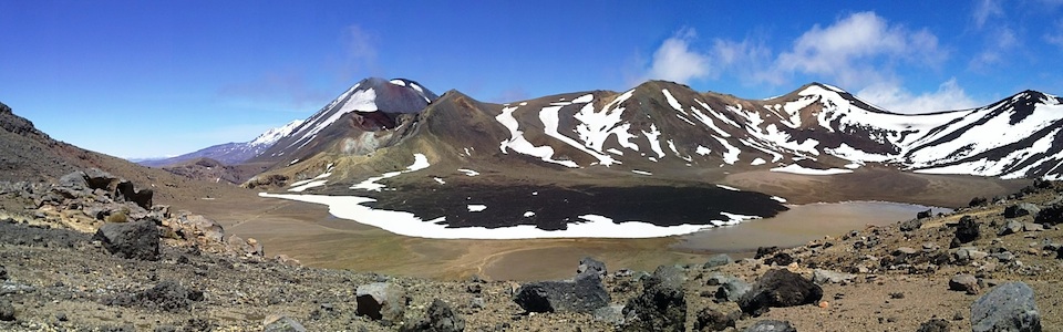
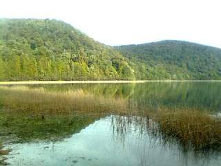
Lake Rotopounamu (Greenstone Lake) is nestled on the side of Mt Pihanga to the east of the Te Ponanga Saddle as you drive toward the Tongariro National Park (SH47). This picturesque lake is great for tree lovers, birdwatchers, walkers and swimming. Rotopounamu was formed by a landslide about 10,000 years ago and is nine meters deep and covers one square km.
Beginning opposite the parking area, the track winds gently uphill through pristine native forest. The left fork in the track at the lake goes to 10 Minute Beach which has a pleasant picnic and swimming spot in summer. The walk up to the lake takes about 20 minutes.
To walk around the lake turn right at the junction and follow a short section of gravel track before dropping down to Five Minute Beach. Further on Long Beach on the eastern side of the lake has a good spot for a picnic and a toilet. Continuing on, you pass Ten Minute Beach and soon return to the track junction from where you follow track downhill to the car park.
Project Tongariro
Since 2003 the Department of Conservation (DOC) and Project Tongariro have been working together to protect the native biodiversity of Mt Pihanga and Lake Rotopounamu through an integrated pest management project, which offers the opportunity to ‘adopt a hectare’ which Riverstone Lodge & Backpackers has done.
Te Pōrere Redoubt Walk
Time: 15 minutes return
Begins: SH47, 26km southwest of Turangi
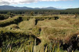
Te Porere Redoubt
In 1869 the last major battle of the New Zealand Wars was fought at Te Pōrere, in the shadow of Mt Tongariro. The war was fought in the East Coast region and across the heavily forested central North Island and Bay of Plenty between New Zealand government military forces and followers of spiritual leader Te Kooti Arikirangi Te Turuki, a Maori ‘prophet’.
A short walk to the left of where you park and over a small bridge will take you to the remarkably well preserved fortifications which also offer some of the closest and best positioned views of Mt Tongariro. The redoubts are an example of the Māori adaptation of classic British military construction techniques.
Te Kooti was defeated by a combined force of Armed Constabulary and Māori fighters, 37 of his warriors were killed and the government forces suffered four losses.Te Kooti continued to avoid his pursuers and sought refuge amongst the Tuhoe Iwi of the Urewera’s and east cape of the North Island.
Te Porere is a remnant of a fascinating series of conflicts between Te Kooti, the crown and ultimately the other Iwi whom the crown commissioned to kill Te Kooti and his followers, and the beginnings of a merging of the beliefs of judeo-christion and Maori mythology.